
By di Red Zone
Four years after the mudslide, survivors struggle for normalcy in Mortomeh and 6 Mile
With its undulating leafy terrain, Mortomeh is one of the more attractive suburban areas of Freetown. Since the 2017 mudslide, though, it stands divided in two: a red zone, which is fenced off, and a safer zone where some displaced survivors now stay.
There are several ways to get to Mortomeh from Freetown, including an uphill 4km drive east from Wilberforce to S S Camp, home to St Paul’s Catholic Church, one of the most important places of worship in the country. Continuing downhill from here leads to Guma Junction, where motorbike-taxis wait to take people to Kowa Drive, the bumpy, unpaved route to Mortomeh. The denuded face of the looming Sugarloaf Mountain where the mudslide originated is difficult to escape: a red gash in a slope of green.
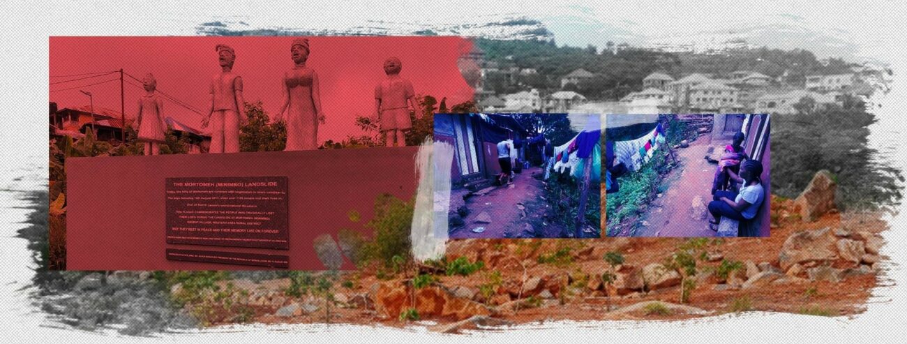
The lanes feeding off Kowa Drive are narrow and unpaved, but many of the houses are solidly built flats or one-storey structures, some with their own verdant kitchen gardens. This impression of a relaxed residential area changes at Prince Allieu Drive, a cement-paved road to the left of Kowa, which leads directly to the Red Zone—the appellation given to the part of Mortomeh at the foot of Sugarloaf Mountain that was destroyed in the mudslide.
A gate and fence made of sticks barricade the Red Zone. Nearby is a zinc house that belongs to Bubu Conteh, a tribal chief who tries to prevent people from going to the disaster area. Surprisingly, the location has not entirely lost its appeal, and there have been reports of people illegally trying to build houses or mine for stones at the foot of Sugarloaf even though it could endanger them and potentially trigger another catastrophe.
Today, though, the Red Zone is deserted, a sprawling wasteland of red, rocky earth, with nothing except a large container that once functioned as a supply store for rescue workers. There are small flashes of greenery amidst the ruins: young bushes sprouting defiantly through the rubble, and a few saplings that women from Regent planted on the ravaged slope and base of Sugarloaf. Closer to the hill flows a stream, once a wata sai (water source) that the long-gone residents once used.
Climbing back up to Prince Allieu Drive, the adjacent Kowa Drive leads to the rest of Mortomeh on the other side of the valley. Some of the displaced victims live here now, but there isn’t enough accommodation to go around. Many people lost their livelihoods in the mudslide too and haven’t been able to regain their stride yet. Some survivors have only found accommodation by becoming ‘caretakers’ for unfinished buildings. There are few comforts and water leaks in during the rains.
“When it rains, I am bailing water out through the night,” says Alie Bangura. “So I had to send my wife and small children upcountry. My eldest son just passed into Class 4. My thought always is how to take care of my son’s school.”
But the life of a caretaker is better than some of the other options, some say. “I wish I could have been a caretaker,” says construction worker Alie Mark Turay. “My family and I were given only a temporary room.”
In many cases, families with six or more members live in single rooms, while others inhabit dilapidated zinc structures, with scraps of wood or tarpaulin tacked on to the roofs and ceilings to prevent rainwater from entering. In this area, people use common toilets and share a water tap attached to a community tank where they pay a small amount of money to fill their containers. In the area, there is a lack of properly constructed gutters; so the water flowing downhill weakens the roads and creates the risk of flooding.
Yet, life goes on. Children shriek excitedly as they play football on the open streets, the kiosks try to do business, and a new mosque is under construction close to the entrance of the community along Kowa Drive.
Alie Bangura, who had to send his wife and children upcountry, is hopeful of better days. “I am a striker (fighter),” he says. “I am learning electrical installation. And when our boss has no work for us, I do nails for some women… I need to do what I can do to provide for my family.
Some 25 kilometres southeast of the Red Zone, in a government-built resettlement camp that has come to be known as ‘Kuwait’, live 64 families who have been relocated from the foothills of Sugarloaf Mountain. They are the ones who suffered the most loss, and residents say they named the camp Kuwait to inspire them to be prosperous like the residents of the Arabic nation.
To get to Kuwait from Freetown, one needs to pass through Waterloo, a buffer town between the chaotic capital and the bucolic Western Area Rural District, and then “upcountry” past a toll booth at Hastings and the settlements of 4 Mile. From this point on, the journey gets a little more complicated. Visitors must first stop at a busy little junction called Crossing and rent a motorbike-taxi. The bike boys waiting near the small kiosks here swarm hopefully around new faces because business is usually slow—not many people visit the government-built camp.
From Crossing, it takes about five minutes on a ‘short-tail’––the smaller motorbikes preferred for their economy and ability to “bear the weather” in Sierra Leone––along an unpaved but relatively smooth scrub-lined road, to reach Kuwait. Along the way is a reminder of another Freetown tragedy: a sign that reads ‘Disaster Resettlement Homes’ and a cluster of homes that were built for the victims of the 2015 floods. A little further down, a baffa (stick structure) and another sign announces the ’2017 Mudslide Flood Resettlement’, where 64 single-storey concrete houses are spread across approximately 20 acres of land dotted with shrubs and low bushes.
At first sight, Kuwait presents an almost idyllic picture, especially when compared with the cramped urban sprawl of Freetown. The houses are comfortably spaced apart, and some are painted in cheerful blue and yellow. Some people have tried to grow a garden, a few chickens stray in the open spaces, there’s a well, a few small businesses—a bright blue kiosk, a tailoring shop—and even a primary school. Children visit each other’s homes and elders often congregate to hold discussions at a thatched pavilion that serves as the unofficial entryway to the community. Life still isn’t easy. The settlement is remote and cut off from the main centres of economic activity and there are few job opportunities. There is no secondary school in the community so children have to walk to Crossing and along the motorway to attend their classes.
The community is tight-knit, but their most powerful bond is the pain and loss they suffered in the 2017 mudslide at Mortomeh, their home four years ago. August in particular is a month of collective mourning.
“Every anniversary brings back bad memories,” says Sarah Kargbo, who lost five children in the disaster. “Whenever I see a small girl helping her mother out with chores, I remember the daughters I lost.”
Steven Tamba Chokpelleh still remembers the last words he heard from his toddler son a day before the disaster: “Papa, tot me.” Steven is trying to cope with the anniversary by reading the scriptures, but grief is a constant companion. “Every time I see a child in the Cardiff school uniform,” he says. “I think about the son I lost.”
By Joshua Yarjah
August 16, 2021
NOTE: This article was first published on 16 August 2021 on www.tieuorja.org, which works to strengthen disaster communication in Sierra Leone.
Additional inputs: Max Seely. Photograph: Joshua Yarjah
Stay with Sierra Express Media, for your trusted place in news!
© 2021, https:. All rights reserved.